Every year, tens of thousands of earthquakes tremble around California. The San Andreas fault, which passes through southern California as the border between the Pacific and North American tectonic plates, is the source of many of these tremors.
The Mojave segment of this fault is predicted to have a major earthquake one day that will be dubbed the “Big One” and rival any other that has occurred in Los Angeles’ history. This earthquake could cause devastating effects over a large portion of Southern California, possibly upending structures and forcing extensive evacuations, if it reaches a magnitude of at least 7.8.
However, research published on December 13 at a meeting of the American Geophysical Union suggests that this event might not be as catastrophic as originally believed, especially close to Los Angeles.
At the moment, the majority of earthquake risk models are derived from ground motion data from previous earthquakes and extrapolations from a small historical timeline. Thankfully, though, another set of sentinels has been seeing and recording these earthquakes for a lot longer than humans: rocks.
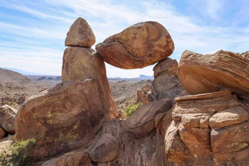
The strength of the shaking during the past 50,000 years can be inferred from a group of five unstable rocks in northern Los Angeles County, California, which are located only 9.3 miles (15 kilometers) from the fault.
The ground will probably shake up to 65% less violently than official danger estimates for the Big One currently predict, according to research using data from these rocks.
Lead researcher Anna Rood, a seismologist at Imperial College London, told Live Science, “basically, the fundamental problem we’re trying to address here is that we’ve been only recording earthquakes with seismometers like not even 100 years.” The potential impact of these infrequent, strong earthquakes on ground trembling is actually unclear. Thus, the geological data is relevant here.
In order to extract secrets from these granite blocks, scientists needed to figure out when they started to become unstable. The soil and sediment were gradually removed from the rocks by time and weather, leaving an excavated base that is more brittle than it was in its whole. Rood and the other co-authors of the paper went to the unstable rocks in 2021 and 2022 to collect samples.
The amounts of beryllium-10, an isotope produced when rocks are exposed to interactions between galactic cosmic rays and the atmosphere, were then measured. When the rocks became more brittle and unstable, the levels that were recorded in them helped to illustrate it.
Additionally, they used high-tech stickers to digitally replicate the size and shape of the rocks, allowing them to simulate the amount of shaking that the rocks could withstand before collapsing.
By calculating the number of earthquakes that these rocks have sustained without collapsing throughout time, the researchers were able to get a notion of the maximum amount of ground motion that may have occurred at the location in the past, far beyond the reach of currently available human recordings.
These results, when compared to the government’s current hazard maps, indicate that there will probably be a lot less ground shaking during the Big One than previously believed.
According to Science, “this is good data,” said Mark Petersen, a geophysicist at the U.S. Geological Survey (USGS), who oversees the creation of the country’s National Seismic Hazard Model. When the maps are updated next month, he added, it’s too early to take the findings into account.
Governments can create building rules and catastrophe preparation strategies with the aid of hazard maps. They are used by insurance companies to estimate the appropriate rate for earthquake insurance in a given region. Rood stated that all of these choices may be impacted if maps are updated to reflect their precarious rock data. She went on to say that while overly cautious construction design isn’t always a bad thing, some projects could end up costing more than they should.
In order to update hazard models, Rood and her research team intend to carry out more studies on dangerous rocks worldwide. Rood expects that instead of being limited to data validation after the fact, these tests will be “built in as part of the process” during hazard modeling in the future.
Topics #Big One #San Andreas